LaTour Demonstration State Forest
LaTour Demonstration State Forest is in Shasta County, approximately 1 hours’ drive East from Redding. It became state property in 1930 when the state exchanged 10,957 acres of scattered state school lands with the USDA Forest Service for the 9,033-acre tract. The property became LaTour Demonstration State Forest in January 1946 when the California State Lands Commission deeded it to the then California Division of Forestry for $100,000.
In 1951 active forest management commenced on the previously unmanaged property, with LaTour’s first timber sale. Through responsible forest management, regular harvesting of merchantable timber and other forest products has continued since. Approximately 200 million board feet have been harvested from LaTour. Current average harvest is between 2-4 million board feet per year. Most of LaTour has been harvested three times.
LaTour Butte is 6,742 feet in elevation and named in honor of James C. LaTour, a blacksmith immigrant who ran a stagecoach station and trading post at Deer Flat. The forest itself was named after the Butte. The LaTour Butte Lookout was built in 1935 and is still staffed periodically during the fire season. The present-day Forest Headquarters was built in 1954. McMullen Mountain is 6,580 feet in elevation and named after James McMullen, an old-time trapper and cattleman. He ranged his cattle in present day Cutter Meadows before the Cutter family acquired the land.
The forest supports ten different coniferous tree species of commercial value. They include sugar pine, ponderosa pine, Jeffrey pine, western white pine, lodgepole pine, Douglas-fir, white fir, red fir, incense-cedar, and mountain hemlock. Pacific yew can also be found in the lower drainages but is much rarer than the others. There is a small hardwood component in the stands as well with the presence of California black oak, canyon live oak, big leaf maple, and red alder.
Typically, the forest is accessible by vehicle from late June until November. The winter and spring months are often a time of high wind, deep snow, and extreme cold, making the area inaccessible to vehicular traffic except by snowmobile. During this time, the forest gates may be locked to protect the road surface, but the forest remains open for all other winter recreation.
Forest Stats:
Established: 1946 as the first Demonstration State Forest
Area: 9,033 acres
Elevation: 3,800 – 6,740 ft.
Precipitation: 46” mainly as snow
Temperature: Max: 90+ F – Min 0 F

Demonstration
Research
LDSF is suited to work with cooperating research partners by writing Timber Harvest Plans that are specifically tailored to meet the needs of current research. Working alongside academic institutions, such as University of Nevada-Reno and Sonoma State, LDSF can meet the legislative research component of the LDSF Forest Management Plan. Current studies are covering topics from Adaptive Silviculture to state-of-the-art inventory methodologies using aerial and terrestrial laser imaging.
Training
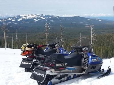
LaTour is part of the Cascade Mountain Range, which makes it a popular location for snowmobiling, hiking, biking, and horseback riding. Hunting and fishing may be enjoyed during the appropriate seasons and in accordance with the California Department of Fish and Wildlife. There are four small primitive campgrounds on LaTour. Campgrounds have a two-week limit per site and are open as long as forest access allows. If you choose to ride horseback, you are required to supply sufficient feed for riding stock. The stock shall not be turned loose to graze, and when secured must be within reach of water and feed. Pets are welcome but must be under the control of the owner at all times.
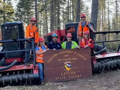
LSDF is committed to working with educational partners such as Shasta College’s Natural Resource program and their Heavy Equipment Logging Operations program. Through these programs LDSF continues to serve as an in-wood classroom to facilitate the education of future land managers and support work force development for resource sector jobs
Hunting may be enjoyed during the appropriate seasons and in accordance with the California Department of Fish and Wildlife.
Please be aware of your surroundings and abide by Local, State and Federal laws.
Cal. Code Regs. tit. 14 § 1413. Weapons.
(a) No person shall discharge any firearm, air or gas weapon, or bow and arrow in the vicinity of camps, residence sites, recreation grounds and areas, and over lakes or other bodies of water adjacent to or within such areas, whereby any person is exposed to injury as a result of such discharge.
(b) Without limiting the foregoing, no person shall discharge any of the above-named weapons or any other weapon while within 150 yards (137.20 m) of any designated camping area.
14 CCR § 1413, 14 CA ADC § 1413
Cal. Code Regs. tit. 14 § 1436. Areas Closed to Hunting and the Use of Firearms.
The following area is closed to hunting and the use of firearms:
(a) Area in Shasta County.
The area of approximately 320 acres (129.504 ha), being a portion of the Latour State Forest immediately surrounding the Latour Forest Headquarters and Forest Fire Station. Said lands being located in Shasta County and being described as follows: lying north and east of McMullen Mountain being the SE 1/4 of Sec. 1 and the NE 1/4 of Sec. 12, T32-N, R2-E, MDB&M.
This area will probably never attract hordes of visitors. There is no unusual scenic beauty, nor natural wonders, nor large body of water for recreational use. It may attract the hunter, fisherman or rare individual who wishes solitude.”
– C.R. CLAR, Protection and Management Plan for LaTour State Forest, 1928
There are 4 campground on LDSF. They are primitive by design, to support the enjoyment of solitude on the mountain.
|
Campground |
Spaces |
Potable Water |
Outhouse |
Picnic Tables |
|
South Cow Creek |
4 |
No |
Yes |
4 |
|
Old Cow Creek |
3 |
No |
Yes |
3 |
|
Butcher Gulch |
2 |
No |
Yes |
2 |
|
Old Station |
4 |
Yes |
Yes |
2 |
LDSF has no trail system at this time and has no development plans for a trail system. During the Summer and Fall months, the roads remain open to public travel except when there is danger due to logging equipment. Many of the roads are suitable for nature walks, sightseeing, or mountain biking. Due to erosion, the use of dirt bikes, mountain bikes, or ATV’s is limited to the forest roads, and all such vehicles in use must have the proper permitting.
Please use caution and abide by the vehicle code.